The Nigeria High Commission London website

Nigeria

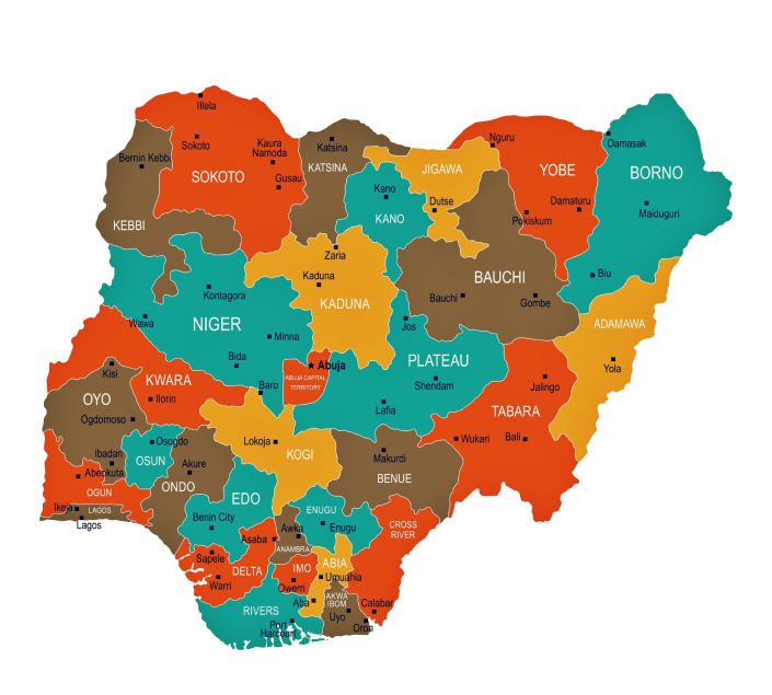
Nigeria is situated in the West African region and lies between longitudes 3 degrees and 14 degrees and latitudes 4 degrees and 14 degrees. It has a land mass of 923,768 sq.km. It is bordered to the north by the Republics of Niger and Tchad; it shares borders to the west with the Republic of Benin, while the Republic of Cameroun shares the eastern borders right down to the shores of the Atlantic Ocean which forms the southern limits of Nigerian Territory. The 800km of coastline confers on the country the potentials of a maritime power. Land is in abundance in Nigeria for agricultural, industrial and commercial activities.

National Anthem

1. Nigeria, we hail thee, our own dear native land,
Though tribes and tongues may differ, In brotherhood we stand
Nigerians all, and proud to serve, our sovereign Motherland.

2. Our flag shall be a symbol, That truth and justice reign,
In peace or battle honoured, And this we count as gain,
To hand on to our children, A banner without stain.

3. O God of all creation, Grant this our one request.
Help us to build a nation, Where no man is oppressed,
And so with peace and plenty, Nigerians may be blessed.

National Pledge

  • I pledge to Nigeria my Country
  • To be faithful, loyal and honest
  • To serve Nigeria with all my strength
  • To defend her unity
  • And uphold her honour and glory
  • So help me God.

Key Data

Three-tier structure - A Federal Government, 36 State Governments, 768 Local Government Administrations and 6 Area Councils of the Federal Capital Territory of Abuja.
Traditional Beliefs, Christianity, Islam
Lagos, Onitsha, Kano, Ibadan, Port Harcourt, Aba, Maiduguri, Jos, Kaduna, Warri, Benin, Calabar
Lagos (Apapa, Tin-can Island), Warri, Port Harcourt, Onne Deep Sea and Hub Port, Calabar (EPZ)
Lagos, Kano, Port Harcourt, Abuja, Enugu, Kaduna, Maiduguri, Ilorin, Jos, Owerri, Calabar, Yola, Sokoto
Over 15,000 km of intercity all weather paved roads, including dual carriage express trunks.
2 main lines (South-West to North-East; South-East to North-West) inter-linked and terminatory at Lagos, Port Harcourt, Kaura Namoda, Maiduguri and Nguru. Major junctions at Kaduna, Kafanchan, Zaria. Gauge: 1067mm; Total length 3505 route km.
Hydro-electric: Kainji, Jebba, Shiroro. Thermal and Gas: Egbin (Lagos), Ughelli, Afam, Sapele, National grid for electricity distribution; National pipeline network with regional depots for petroleum products distribution; National network (pipeline) for distribution of gas (under construction).

Other Data

Geography
Nigeria is situated in the West African region and lies between longitudes 3 degrees and 14 degrees and latitudes 4 degrees and 14 degrees. It has a land mass of 923,768 sq.km. It is bordered to the north by the Republics of Niger and Tchad; it shares borders to the west with the Republic of Benin, while the Republic of Cameroun shares the eastern borders right down to the shores of the Atlantic Ocean which forms the southern limits of Nigerian Territory. The 800km of coastline confers on the country the potentials of a maritime power. Land is in abundance in Nigeria for agricultural, industrial and commercial activities. At its widest, Nigeria measures about 1,200 km from east to west and about 1,050 km from north to south. The country's topography ranges from lowlands along the coast and in the lower Niger Valley to high plateaus in the north and mountains along the eastern border. Much of the country is laced with productive rivers. Nigeria's ecology varies from tropical forest in the south to dry savanna in the far north, yielding a diverse mix of plant and animal life. The broad, mostly level valleys of the Niger and Benue rivers form Nigeria's largest physical region. The Niger enters the country from the northwest, the Benue from the northeast; the two rivers join in Lokoja in the south central region and continue south, where they empty into the Atlantic at the Niger Delta. Together, they form the shape of a Y. Population densities and agricultural development are generally lower in the Niger and Benue valleys than in other areas. North of the Niger Valley are the high plains of Hausaland, an area of relatively level topography averaging about 800 m above sea level, with isolated granite outcroppings. The Jos Plateau, located close to Nigeria's geographic center, rises steeply above the surrounding plains to an average elevation of about 1,300 m. To the northeast, the plains of Hausaland grade into the basin of Lake Chad; the area is characterized by somewhat lower elevations, level terrain, and sandy soils. To the northwest, the high plains descend into the Sokoto lowland. Southwest of the Niger Valley (on the left side of the Y) lies the comparatively rugged terrain of the Yoruba highlands. Between the highlands and the ocean runs a coastal plain averaging 80 km in width from the border of Benin to the Niger Delta. The delta, which lies at the base of the Y and separates the southwestern coast from the southeastern coast, is 36,000 sq km of low-lying, swampy terrain and multiple channels through which the waters of the great river empty into the ocean. Several of the delta's channels and some of the inshore lagoons can be navigated. Southeastern coastal Nigeria (to the right of the Y) consists of low sedimentary plains that are essentially an extension of the southwestern coastal plains. In all, the Atlantic coastline extends for 850 km. It is marked by a series of sandbars, backed by lagoons of brackish water that support the growth of mangroves. Large parts of Africa's Bight of Benin and Bight of Biafra fall along the coast. Because of the Guinea Current, which transports and deposits large amounts of sand, the coastline is quite straight and has few good natural harbors. The harbors that do exist must be constantly dredged to remove deposited sand. Inland from the southeastern coast are progressively higher regions. In some areas, such as the Udi Hills northwest of Enugu, escarpments have been formed by dipping rock strata. Farther east, along Nigeria's border with Cameroon, lie the eastern highlands, made of several distinct ranges and plateaus, including the Mandara Mountains, the Shebeshi Mountains, the Alantika Mountains, and the Mambila Mountains. In the Shebeshi is Dimlang (Vogel Peak), which at 2,042 m is Nigeria's highest point.
Climate
Temperatures across the country is relatively high with a very narrow variation in seasonal and diurnal ranges (22-36t). There are two basic seasons; wet season which lasts from April to October; and the dry season which lasts from November till March. The dry season commences with Harmattan, a dry chilly spell that lasts till February and is associated with lower temperatures, a dusty and hazy atmosphere brought about by the North-Easterly winds blowing from the Arabian peninsular across the Sahara; the second half of the dry season, February - March, is the hottest period of the year when temperatures range from 33 to 38 degrees centigrade. The extremes of the wet season are felt on the southeastern coast where annual rainfall might reach a high of 330cm; while the extremes of the dry season, in aridity and high temperatures, are felt in the north third of the country.
Vegetation
In line with the rainfall distribution, a wetter south and a drier northern half, there are two broad vegetation types: Forests and Savanna. There are three variants of each, running as near parallel bands east to west across the country. Forests Savanna Saline water swamp Guinea Savanna Fresh water swamp Sudan Savanna Tropical (high) evergreen Sahel Savanna Rainforest. There is also the mountain vegetation of the isolated high plateau regions on the far eastern extremes of the country (Jos, Mambilla, Obudu). The savanna, especially Guinea and Sudan, are the major grains, grasses, tubers, vegetable and cotton growing regions. The Tropical evergreen rain forest belt bears timber production and forest development, production of cassava; and plantation growing of fruit trees - citrus, oil palm, cocoa, rubber, among others.
Nigeria is famous for her huge population of about 140,003,542 as at March 2006 - the largest national population on the African continent. This population is made up of about 374 distinct ethnic stocks. Three of them, Hausa, Ibo and Yoruba are the major groups and constitute over 40 per cent of the population. In fact, about 10 ethnic linguistic groups constitute more than 80% of the population: the other large groups are Tiv, Ibibio, Ijaw, Kanuri, Nupe, Gwari, Igala, Jukun, Idoma, Fulani, Edo, Urhobo and Ijaw. The gender divide of Nigeria's population, as indicated by the last census in 1991, reflects an unusual unbalance in favour of male dominance; 51% male: 49% female.

However, the more critical population indices concern:

  • High growth rate - 3.2%; this is affected by decreased infant mortality andhigh fertility.
  • High school age population - over 47% are 15 years and below.
  • High child dependency ratio - one dependant to one worker for the working age group 25-65.
  • Large work force - working age group 15-59 is over 40 per cent of the population.

Due to a massive expansion in the education sector in the last two decades, the coloration and quality of the Nigerian work force has changed to include a large corps of highly trained personnel in mechanical, civil, electrical, electronics, chemical and petroleum engineering and biotechnics. There are at present over 30 Federal and State Universities, some of them specialist - Technology and Agriculture. In addition there are at least 20 Federal and State Polytechnics. Over 70,000 graduates in various disciplines from these institutions every year. Disciplines, apart from pure sciences, engineering and technologies, include social sciences, business studies (management, banking and finance), architecture, environment and urban management studies. Also, a sizeable Nigerian population has been and is being trained outside the country, in some of the best colleges in the United States, Canada, United Kingdom, Germany, France, Russia, Japan and China. Every year, about 2,000 of these Nigerians return home to seek employment or accommodation within the economy. For the less skilled and unskilled labour, the country depends on the primary and secondary school systems whose annual enrolments are over 3.5 million and 1.5 million, respectively.

Nigeria, in addition to its huge population is endowed with significant agricultural, mineral, marine and forest resources. Its multiple vegetation zones, plentiful rain, surface water and underground water resources and moderate climatic extremes, allow for production of diverse food and cash crops. Over 60 per cent of the population is involved in the production of the food crops such as cassava, maize, rice, yams, various beans and legumes, soya, sorghum, ginger, onions, tomatoes, melons and vegetable. The main cash crops are cocoa, cotton, groundnuts, oil palm and rubber. Extractions from these for export and local industrial use include cocoa flour and butter, rubber crumb, vegetable oil, cotton fibre and yarn. The rain forests have been well exploited for timber and wood products of exotic and popular species. Oil and Gas, by value, are the most important minerals. They are exploited and produced in the Niger Delta basin and off-shore on the continental shelf and in the deep-sea of the territorial waters. Nevertheless, there are significant non-oil mineral deposits on land many of which have been identified and evaluated: coal, iron ore, gypsum, kaolin, phosphates, lime -stone, marble, columbine, baryte and gold.
Know about our Economy
With a population of over 140 million people, Nigeria is obviously the largest market in sub Saharan Africa with reasonably skilled and potential manpower for the efficient and effective management of investment projects within the country. It is well connected by a wide network of motorable all-season roads, railway tracks, inland waterways, maritime and air transportation.Nigeria's economy could be aptly described as most promising. It is a mixed economy and accommodates all corners, individuals, corporate organisations and government agencies, to invest in almost all range of economic activities. Since 1995, the Government has introduced some bold economic measures, which have had a salutary effect on the economy by halting the declining growth in the productive sectors and putting a stop to galloping inflation; they have reduced the debt burden, stabilised the exchange rate of the Naira and corrected the balance of payments disequilibrium. In Successive budgets, since May 1999 when civil rule was restored to the country, Government put in place some fiscal measures, which addressed the exchange rate regime and the capital flight issue, which hitherto inhibited project planning and execution. The policy of expanded production through guided deregulation has paid off with the economy recording a real growth of over 3.2% of GDP. The rate of inflation declined appreciably.
Read more
Scroll to Top
The Nigerian Coat of arms
NIGERIA HIGH COMMISSION

Nigeria House, 9 Northumberland Avenue, London WC2N 5BX.
Telephone: 020 7839 1244 Fax: 020 7839 8746
Email: hc@nigeriahc.org.uk

NOTICE OF PUBLIC HOLIDAY

The High Commission wishes to inform the general public that it will be closed for the Christmas and New Year holidays from Monday, 16 December 2024, to Friday, 03 January 2025. During this period, the High Commission will suspend all services except Immigration Services. Regular operations will resume on Monday, 06 January 2025. Applicants with biometric appointments scheduled during the holiday closure are advised to proceed with their appointments as scheduled. However, all other services will only be available from Monday, 06 January 2025.

The Acting High Commissioner extends warm wishes to the public for a joyful Christmas and prosperous New Year.